


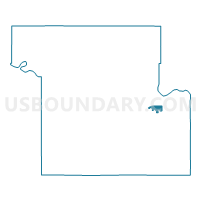
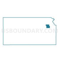
Cheyenne Voting District, Shawnee County, Kansas
About
Outline

Summary
| Unique Area Identifier | 587182 |
| Name | Cheyenne Voting District |
| County | Shawnee County |
| State | Kansas |
| Area (square miles) | 1.21 |
| Land Area (square miles) | 1.20 |
| Water Area (square miles) | 0.01 |
| % of Land Area | 99.07 |
| % of Water Area | 0.93 |
| Latitude of the Internal Point | 39.02502310 |
| Longtitude of the Internal Point | -95.60194910 |
Maps

Graphs
Select a template below for downloading or customizing gragh for Cheyenne Voting District, Shawnee County, Kansas


Neighbors
Neighoring Voting District (by Name) Neighboring Voting District on the Map
- East Peck Voting District, Shawnee County, KS
- Kaw Voting District, Shawnee County, KS
- Kiowa Voting District, Shawnee County, KS
- Peck Voting District, Shawnee County, KS
- Ponca Voting District, Shawnee County, KS
- Topeka Ward 4 Precinct 13, Shawnee County, KS
- Topeka Ward 5 Precinct 01, Shawnee County, KS
- Topeka Ward 5 Precinct 14, Shawnee County, KS
Top 10 Neighboring County Subdivision (by Population) Neighboring County Subdivision on the Map
Top 10 Neighboring Place (by Population) Neighboring Place on the Map
Top 10 Neighboring Unified School District (by Population) Neighboring Unified School District on the Map
Top 10 Neighboring State Legislative District Lower Chamber (by Population) Neighboring State Legislative District Lower Chamber on the Map
- State House District 53, KS (23,340)
- State House District 57, KS (21,197)
- State House District 58, KS (21,153)